Parang L Trek
An High Altitude Trek in the Himalayas. From Spiti To Kazok ( Ladhak)
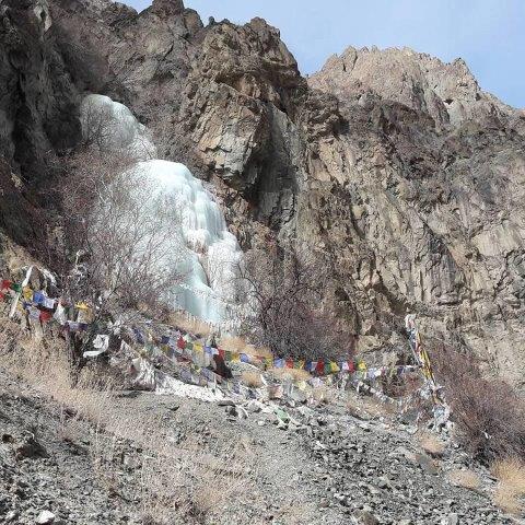
Overview :

Parang La is a great and unique trek that starts in Spiti and ends in Ladakh on the banks of Tso Moriri Lake. Following is the itinerary for the same.

Before the advent of modern transportation there existed an ancient trekking route (Parang La - 5575m) - over the high mountains of Spiti, over long glaciers, through wind eroded valleys, above vast eastern plains - which connected the people of Ladakh to the rest of the world.
Yak and camel caravans would walk over Green Meadows of Dumla, climb down the gorge of Kibber nala, up the scree slopes to the top of the pass where prayer flags carried chants to Gods, on the other side they slid down a long river of ice, snaked oneself through the wind carved valleys, crossed waist deep streams, to reach the vast and beautiful plains of Kiangdom on the banks of Tso Moriri.
Ladakhis would bring salt, wool, gemstones, etc and Spitians would exchange that with barley, peas, potatoes.  This traditional trade post existed until the 1962 Sino-Indian war.
Let us take you back in time over this age-old trade route; once the highway to Ladakh - Parang La Pass from Kibber to Korzok.
Itinerary
Day 1 : New Delhi to Chandigarh / Shimla.
Arrive in New Delhi. Drive / Fly/ Train to Chandigarh / Shima. Overnight In Chandigarh / Shimla. Lunch on the way. Check In a
Day 2 : Chandigarh / Shimla to Kaza
A long mountain drive to Kaza, will start early in the morning with lunch enroute. Arrive by late evening. Dinner in a motel in Kaza. Overnight in Kaza
Day 3 : Kaza : Acclimatisation Day. The day with light activity. Lunch & Dinner in the motel. Do light activity so that acclimatisation takes place.
Day 4 : Kaza to Kibber.
After breakfast, take a short drive to Kibber. Visit famous Kibber monastery. Lunch and Dinner at motel in Kaza.

Day 5 : Kibber to Dumla (Altitude : 4300 meters ) : Duration : 3 Hours

After breakfast start the first day of the trek. Today's is an easy trek for 2hrs from Kibber to Dumla. The trails descends down to the Kibber Nala initially and then ascends gradually till we reach the meadows of Dumla. Relax and acclimatize, lazing near the stream for rest of the day. Overnight In Dumla.

Day 6 : Dumla to Thalthak (Altitude : 4600 meters ) : Duration : 5 Hours

Highlight of the today’s trek is the altitude gain and ascend to the campsite of Thalthak. The trail climbs up from the meadows of Dumla for 4-5 hrs and descends to a small stream near the meadows. Overnight in Thalthak.

Day 7 : Thalthak to Bongrojen (Altitude : 5000 meters ) : Duration : 7 Hours

This is the toughest part of the trek. The trail descends all the way down to Parilungbi Chu first. After crossing the river over footbridge it continues along the river for 2 kms till you reach Jagtha. From Jagtha it’s a continuous ascent till we reach Bongrogen, the base camp for Parang La. Overnight in Bongrogen.

Day 8 : Bongrojen to Parang La to Karsha Gongma : (Altitude : 4600 meters ) : Duration : 7 Hours.

This is what you were dreaming about since you heard about Parang La. We rise early, after having breakfast we start towards Parang La by 5am. The trail ascends gradually and then as we reach closer to the ridge the trails zigzags its way up to Parang La, where the prayer flags carry the chants to Gods. On the other side along river of ice awaits. Click as many photos on top of the pass. We walk over the Parang Chu glacier for 3-4kms till we reach it snout. As accomplishment overwhelms you the trail flattens out and continues on the west bank of the Parang chu river till you reach the campsite of Dak Karzong. Overnight in Karsha Gongma.

Day 9 : Karsha Gongma to Datang Yongma : (Altitude : 4550 meters ) : Duration : 5 Hours.

The first of many river crossing awaits you after breakfast. The Parang Chu increases its flow as the day gets sunnier. We cross the Parang Chu river and walk along its right bank till we reach a green meadow amidst the dry landscape - Datang Yongma. You will cross several streams along the way. Overnight in Datang Yongma.

Day 10 : Datang Yongma to Norbu Sumdo : (Altitude : 4520 meters ) : Duration : 6 Hours.

The last and the biggest of the river crossings lies ahead of you. We cross the Parang Chu river for last time during this trek. Watch out for the mules crossing the river and use your camera to capture this amazing bond between, mules and mountains. The trail ascends to the left side as you leave the river and continue towards Changthang. Watch out for the ancient dilapidated post office building. The trail is flat from here all the way till Tso Moriri, stop for lunch at Chumik Shilde and continue ahead. Look for numerous Marmots peeking from their burrows, wild ass galloping on marshes and maybe a wolf. The vast plains of Kiangdom lay bare contrasting its colour with the lake in front of you. You will see the campsite and as you keep moving you'll understand the deception that these mountains have for you.

Day 11 : Kiangdom to Karzok : (Altitude : 4550 meters ) : Duration : 7 Hours.

Last day of the trek, but not the least. A long day of trek for 24 kms is what takes you to Korzok from where we can head to Leh. The trail though is no ordinary, as you walk along the shores of the Tso Moriri throughout the day, you see the lake changing its colors as move from one step to another. You'll camp at Korzok for the night.

Day 12 : Karzok to Leh :

After breakfast drive to Leh town. Lunch on the way. Arrive in Leh. Tansfer to a hotel. Dinner and Overnight in Leh.

Day 13 : Rest day to spend some time in Leh town. Option of doing local sightseeing.
Overnight in Leh.

Day 14 : Transfer to Leh Airport.  Fly to New Delhi. Upon arrival transfer to a hotel in New Delhi. Overnight in New Delhi

Day 15 : Transfer to New Delhi International Airport. TOUR ENDS